A field journal by PackTrack
Can You Camp on Crown Land in Ontario?
I wanted a quiet, off-the-beaten-path Ontario weekend after every decent site was booked. That sent me down a rabbit hole into Crown land, CLUPA, and what’s actually legal.
I was trying to plan a weekend trip this summer and hit a wall. Every site I actually wanted was already booked up. The private spots that were left were weirdly expensive for what they were. And meanwhile I kept watching these YouTube videos of people camping on obscure, off-the-beaten-path lakes that looked absolutely sick, no reservation, no fee, no crowd. So I went down a rabbit hole trying to figure out where these people were actually camping, and whether it was even legal. The answer, it turns out, is Crown land. So here’s what I learned.
The short answer
Yes, mostly.
Camping is free on most Crown land in Ontario. If you’re a Canadian resident you don’t need a permit, and you can stay up to 21 days on any one site per calendar year. After that you move at least 100 metres.
That’s the whole rule for the common case, and there’s a lot of it: Crown land makes up something like 90 percent of northern Ontario. Free, legal, quiet.
Free, no permit, up to 21 days per site if you’re a Canadian resident. That covers most trips.
“Crown land” just means public land the province manages. And to be clear on what it isn’t: it does not include provincial parks like Algonquin, Killarney, and the rest, or conservation reserves.
A provincial park is the nice easy option, you pay per night and you’re sorted, but campsite permits can run well over a hundred bucks for a few nights with a couple of people. Crown land is the free alternative.
The catch is that you have to do a little homework.
Where it gets less clean
This is the part where most posts kind of wave their hands and move on.
“Most” Crown land is not “all” Crown land. And the annoying part is that Crown land isn’t one thing. The province carves it into a bunch of different land designations, each with its own rules about what you’re allowed to do there.
So you can’t just see “public land” on a map and pitch a tent.
You can’t camp where:
- there’s posted signage restricting or banning it
- the official land use policy for that area says recreational activities aren’t permitted
- someone else is authorized to use the land, like a land use permit, a mining lease, etc.
- it’s posted under the Trespass to Property Act
- you’re in the Far North and it conflicts with a Community Based Land Use Plan
Two spots can look identical on a map and have completely different rules. One’s open for 21 days free, the next lake over sits inside a designation that quietly bans camping, or turns out to be private cottage land right on the shoreline.
The map alone won’t tell you. You have to check the actual designation for that exact spot.
What you’re usually looking for
The designations you’re generally looking for are General Use Area and Enhanced Management Area, that’s where free camping is usually fine.
Conservation reserves are the ones to avoid. Some don’t even allow fishing. Useless lol.
Also watch for private land, because a surprising number of lakes have cottages lining the shore that look like open bush until you check.
If you’re not a Canadian resident
The free-and-easy version is for residents.
If you’re a non-resident of Canada, you need a Crown land camping permit to camp north of the French and Mattawa Rivers. There are exceptions, like renting your gear from an Ontario business or camping as part of a job in Canada.
Non-residents also can’t camp in certain designated green zones at all.
But that’s where most of my knowledge around this ends, so I’ll leave it to you to figure out if you’re not a Canadian resident.
So how do you actually know if a spot is legal?
This is the part that sent me down the rabbit hole in the first place.
The government’s own answer is: look up your spot in the Crown Land Use Policy Atlas before you go.
And it’s a real tool, it genuinely has the answers. But dude if you’ve ever opened it, you know the problem. It’s a slow, clunky desktop GIS site. There are entire 20-minute YouTube tutorials just teaching people which tabs to click and how to read the legend.
It’s fine at a kitchen table with two monitors. It’s completely useless when you’re standing at a put-in with one bar of signal trying to figure out if the lake in front of you is fair game.
And even once you’ve got the designation, the atlas doesn’t show you how to get there. No access roads, no put-ins, nothing. So you’re cross-referencing it against Google Earth and a couple of guidebooks just to turn “this is legal” into “and here’s how I actually reach it.”
This is why I built it into PackTrack
That whole gap, knowing a spot exists versus knowing it’s legal versus knowing how to get to it, is exactly the problem I couldn’t solve while planning that trip. So I ended up building most of it into PackTrack.
It pulls the same official land use designations, but instead of making you suffer through the atlas, you just long-press a spot on the map and it tells you the verdict for that exact location, plus which designation it’s in and why.
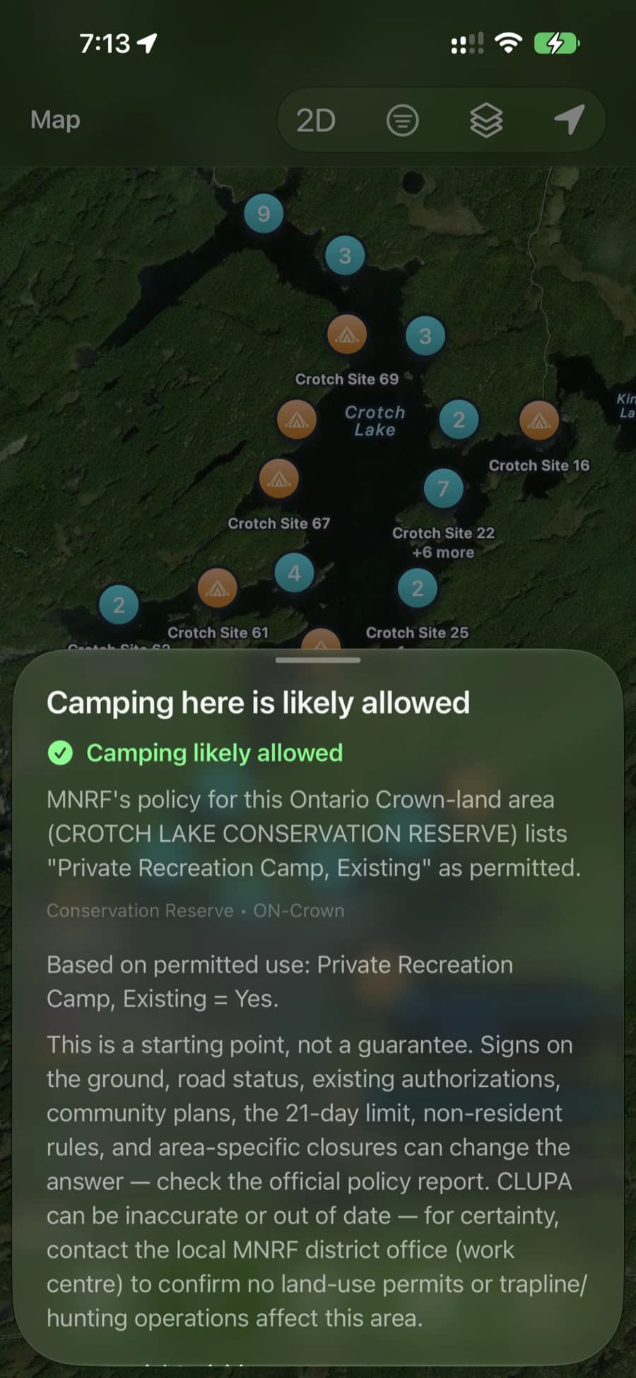
So you can go from “that lake looks sick” to “yeah, that’s likely allowed, here’s the designation, and here’s why” without a browser tab in sight.
The actual takeaway
Camping on Crown land in Ontario is one of the best deals going. Free, legal, quiet, and there is a genuinely huge amount of it.
The only real work is confirming that the specific spot you want is actually open, because “most” isn’t “all.” Check the designation, watch for signage and private land, and have a backup in case your first pick is closed or occupied.